HIWAI project
Homogenized seIsmic full WAveform Inversion and downscaling
Seismic imaging is an effective tool to investigate the earth interior for academic and industrial purposes, from scales of a few meters to the global Earth. Recently, seismic imaging techniques based on the Full Waveform Inversion (FWI) of active (explosion or airgun) or passive (earthquakes) sources seismic records have made important progress. It has now reached the point where FWI is a credible technique for realistic 3-D imaging of geological structures and intensive researches on this subject are carried out by both academic institutions and the oil industry. Nevertheless, for many applications, these techniques remain a huge challenge from both technical and theoretical point of view. So far, FWI are built as a linearized and regularized least squares optimization problem and the challenges linked to local minima of the misfit function, non-uniqueness of the solution, interpretation and uncertainties of the obtained images, and the huge computational cost strongly limit the application range of such methods.
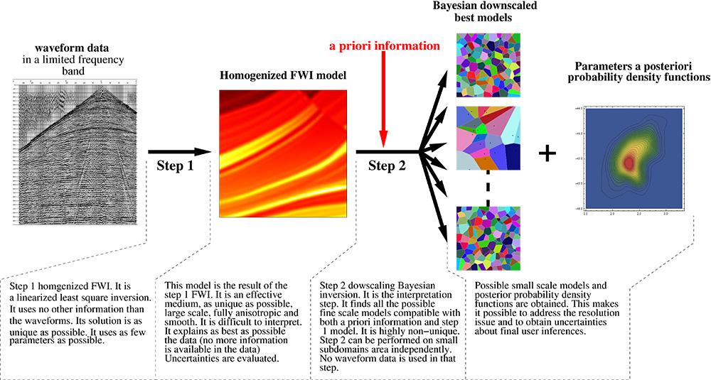
The main objective of the HIWAI project is to widely extend the range of applications of FWI methods to important domains of societal and scientific interest by developing an alternative and innovative approach based on two new tools recently developed by our teams: the non-periodic homogenization and Bayesian downscaling techniques. A 2-steps inversion will be developed, leading to a method close to a fully probabilistic approach of the inverse problem, a solution commonly considered as out of reach for current computers when based on full waveform forward problem. If successful, this will be a significant breakthrough.
Among the possible applications where the proposed method will bring a significant improvement, highly contrasted media are of particular interest. Such media, which can often overturn current FWI techniques, can be commonly found, at the civil engineer scale, in natural hazard key issues such as foundation survey, cavities and potential collapse detections, and, at the oil exploration scale, characterization of complex reservoirs. The obtained models will also be particularly well suited for applications where good quality data prediction is necessary (e.g. nuclear monitoring, earthquake
nucleation, seismic risk assessment). Important improvements are also expected in applications where the interpretation of seismic images and quantitative answers to precise questions are required (e.g. what is probability to find a high water content in a given area, or is the observed anisotropy intrinsic or only apparent? How connected is the fault network of a given oil reservoir?). Even if the proposed developments can be applied to any scale, during the project the method will be developed and tested for local to regional scale applications.
The project is organized in 4 tasks: 1) 2-D FWI in the homogenized space (step 1 inversion), 2) 2-D downscaling inversion (step 2 inversion), 3) reduced scale analogue data generation for testing the inversion schemes, 4) 3-D developments. Through a collaborative project (PRC instrument), all the necessary skills will be gathered involving 5 partners: homogenization and inversion (LPGNantes), seismic inversion and oil prospection scale imaging (SEISCOPE2, Grenoble), experimental seismic modeling at reduced scale and seismic imaging of the near surface (IFSTTAR, Bouguenais), Bayesian inversion (ENS Lyon) and Geomodeling (RING, Nancy). The project tackles a novel fundamental theoretical approach for which the early developments and tests will be driven by the needs at different scales. It will provide a long term research subject which will naturally lead to further applied projects, implying industrial partners, for tackling societal and academic problematics at various scales.
The project coordinator is Yann Capdeville, CNRS researcher.