24 avril 2024
Angers Autumn School “Foraminifères et Géochimie”
L’École d’Automne d’Angers AAS – Édition 2024, intitulée “Foraminifères et Géochimie”, se déroulera du 30 septembre au 4 octobre 2024, à l’Université d’Angers. Cette école proposera une approche innovante de l’étude des environnements côtiers, centrée sur l’analyse des foraminifères vivants et la géochimie des sédiments. Des conférences théoriques et des ateliers pratiques seront organisés pour […]
2 avril 2024
Sujets de thèses proposés au LPG en 2024
1- The role of ice on the formation of martian valley networks Thousands of valley networks incise the Martian southern hemispheric highlands, and stand as a reflect of an ancient past characterized by active hydrology and surface liquid water. After a peak of valley network formation around ~3.8 Byr ago (Gya), surface water presence and […]
29 mars 2024
Colloque Planetoexobio2024 : Colloque Français en Planétologie et Exobiologie du 1 au 5 juillet à Nantes
Le colloque Planetoexobio2024 est la première conférence nationale française d’une semaine combinant les sciences planétaires et l’astrobiologie.Elle est le résultat d’une collaboration entre le Programme d’Équipement de Recherche Prioritaire (PEPR) “Origines”, Programme National de Planétologie (PNP), Société Française d’Exobiologie (SFE) et le Hub français de l’Europlanet Society.Les contributions sur tous les thèmes couverts par le […]
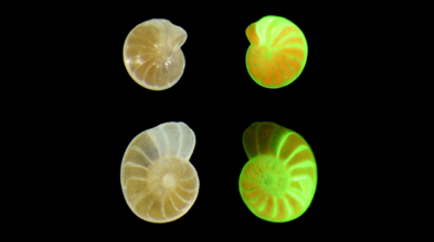
15 mars 2024
Impacts potentiels de l’activité des cable bacteria sur les foraminifères benthiques à coquille indurée : implications pour leur interprétation comme bioindicateurs ou paléoproxis
L’effet de l’acidification des sédiments marins côtiers par les cable bacteria sur les foraminifères a été documenté dans les vasières intertidales de la rivière d’Auray (Morbihan, 56). Cette forte diminution du pH (1 < ∆pH < 2.4) entraîne la dissolution des tests carbonatés des foraminifères vivants et morts, menaçant la préservation des tests dans les […]
13 mars 2024
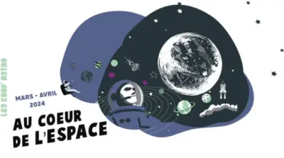
Conférences « Au cœur de l’Espace » édition 2024
Terre des Sciences, le Laboratoire de planétologie et géosciences, Curiosity-ESEO, EU*Asia Institute de l’ESSCA et Ciel d’Anjou, vous emmènent dans leur fusée vivre de nouvelles aventures « Au cœur de l’espace » ! Du 20 mars au 17 avril à 19h15, des conférences gratuites et accessibles au grand public (à partir de 10 ans) sont programmées à […]
11 mars 2024
Emplois
Actuellement, deux profils d’enseignant-chercheur, d’ATER, un post-doctorat et un poste de technicien.ne en gestion financière et administrative sont proposés : 1- Le Laboratoire de Planétologie et Géosciences et le département des Sciences de la Terre et de Nantes Université vont recruter un maître de conférences ou une maîtresse de conférences, dans le domaine de la […]
22 février 2024
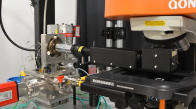
Un spectromètre Raman pour étudier la matière organique complexe
Le projet ERC Promises porte l’ambition de comprendre le rôle de la matière organique complexe en interaction avec l’eau et les roches à haute-pression dans les conditions des lunes de glaces de Jupiter et de Saturne. Pour répondre expérimentalement à cette question, le LPG mène des expériences à haute-pression (7 GPA) et haute température (800 […]
12 février 2024
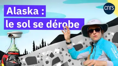
Découvrez le reportage “Alaska : le sol se dérobe” avec Susan Conway, planétologue CNRS !
L’Alaska subit de plein fouet le changement climatique. Avec la hausse des températures, le pergélisol, ce sol gelé en permanence, se dégrade et les glissements de terrain se multiplient, menaçant des villages. Dans cette vidéo diffusée avec LeMonde.fr, rejoignez sur le terrain les scientifiques qui tentent de comprendre ce qu’il se trame sous terre. Ce […]
8 février 2024
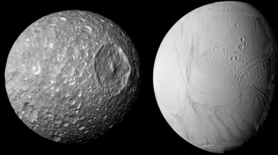
Naissance d’un océan sur la lune de Saturne, Mimas
S’il y a bien un objet dans le Système solaire au sein duquel l’on ne s’attendait pas à trouver de l’eau à l’état liquide, c’est sans nul doute Mimas. À la différence de sa grande sœur Encelade, la surface de Mimas est extrêmement cratérisée et inactive, ne témoignant d’aucun signe d’activité sous sa surface. De […]